
As solar power capacity continues to grow across Estonia and Europe, knowing how much sunlight actually reaches the ground becomes increasingly important. Accurate irradiance estimates help solar park operators monitor production, detect faults, and improve energy planning. Yet measuring sunlight everywhere with ground instruments alone is impossible.
The challenge lies in estimating Surface Solar Irradiance (SSI) – the amount of solar radiation reaching the Earth’s surface. While SSI can be measured accurately at individual weather stations, estimating it continuously across an entire country remains a much more difficult task.
STACC data scientist Gordei Pribõtkin examined this problem in his University of Tartu master’s research, supervised by Piia Post (PhD) and Velle Toll (PhD). The research explores whether a new generation of European weather satellites, which observe the Earth at substantially higher spatial resolution, can improve machine-learning-based estimates of solar irradiance over Estonia. A scientific article based on the work is currently under review at Solar Energy.
Ground measurements are accurate but sparse
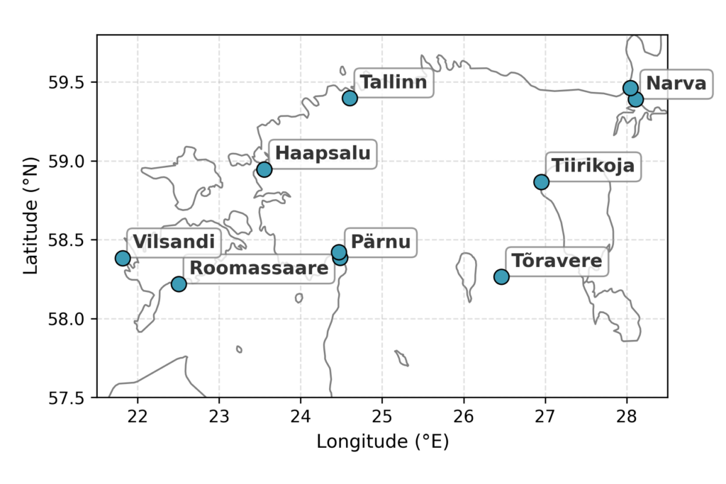
The reference instrument for solar irradiance is the pyranometer, installed at meteorological stations. Its readings are accurate, but each one describes a single location. The ground truth in this study came from eight meteorological stations across Estonia, which is far too few to characterise irradiance over the entire country, see Figure 1. Estimating SSI everywhere therefore requires either physical models or remote sensing from satellites.
Existing satellite products are coarse in space and time
Established solar-radiation products for Europe, such as SARAH-3 and CAMS, are derived from satellite observations using physics-based models. They are well validated and widely used, but their resolution constrains local applications. SARAH-3 provides estimates on a grid of roughly 5.6 km, and CAMS at approximately 11 km, with temporal resolutions of 30 and 15 minutes respectively. These scales are appropriate for climatological work, but too coarse to represent conditions at an individual solar plant on a given afternoon.
Meteosat Third Generation offers a substantially higher-resolution view
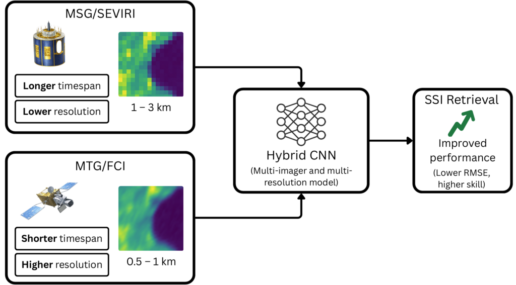
The recently introduced Meteosat Third Generation (MTG) satellites carry the Flexible Combined Imager (FCI), which provides imagery at approximately 0.5 to 1 km spatial resolution. This is a marked improvement over the previous-generation Meteosat Second Generation (MSG) and its SEVIRI imager, which operate at 1 to 3 km, and FCI also offers finer spectral resolution.
There is a clear physical reason why this improvement matters. Higher spatial resolution allows the satellite to resolve smaller-scale cloud structure, and clouds are the dominant source of short-term variability in surface irradiance. Better-resolved cloud information should, in principle, support more accurate irradiance estimates.
The main limitation is data availability. At the time of the experiments, only about one year of MTG data existed, whereas MSG provides a multi-year record. Because machine learning models benefit from long training records, the central methodological question was how to obtain the accuracy of the newer, higher-resolution imager without sacrificing the depth of the older archive.
A multi-branch convolutional neural network that combines both imagers
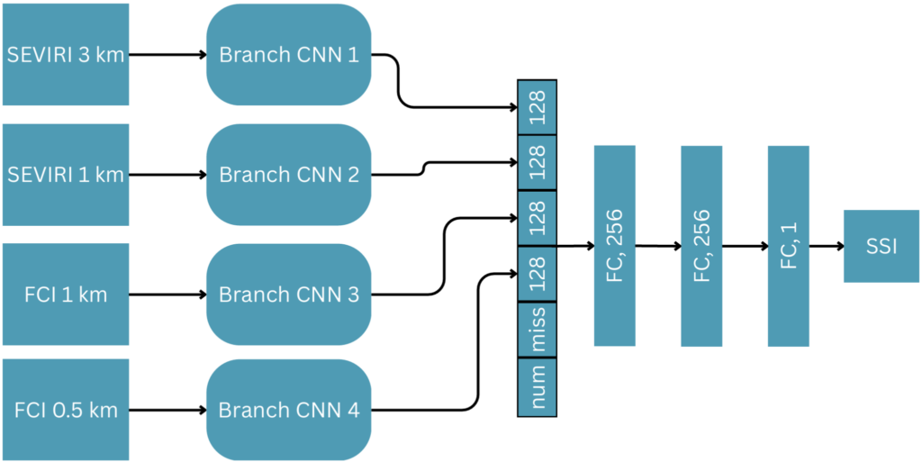
Rather than choosing between the two satellite generations, the model combines their strengths. It is a multi-imager, multi-resolution convolutional neural network (CNN) that produces SSI estimates at 10-minute intervals for locations across Estonia.
For each ground station, the model extracts image patches centred on that location from the satellite views. Each image type is processed by its own branch of the network: separate branches for the SEVIRI images at 3 km and 1 km, and separate branches for the FCI images at 1 km and 0.5 km. Every branch is a small CNN that learns to extract the relevant features from its input. The branch outputs are then combined with a set of numerical inputs – solar position, time of day and time of year, geographic location, and a clear-sky irradiance reference – and passed through the network’s final layers to produce a solar radiance estimate at a given point.
The two satellites are combined through a hybrid training procedure. The SEVIRI branches are first trained on five years of MSG data to establish a stable representation. Those branches are then frozen, and the FCI branches are trained on the single year of MTG data available. This retains the information contained in the longer MSG record while incorporating the higher resolution of the MTG imagery, rather than trading one against the other.
Performance was assessed with site-based cross-validation across the eight stations and repeated over multiple training runs. This makes it possible to quantify the uncertainty in the results and distinguish genuine, repeatable performance from run-to-run variation, which many earlier single-model studies did not report.
The higher-resolution imagery helps most under cloudy conditions
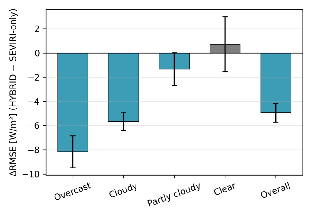
The results show that the additional spatial resolution is most beneficial under cloudy conditions, where estimating irradiance is the most challenging. Compared with a model using MSG data alone, the hybrid MSG-plus-MTG model reduced the root-mean-square error (RMSE) by approximately 4.9 W/m² overall, and by 8.2 W/m² and 5.7 W/m² under overcast and cloudy skies, see Figure 4. This corresponds to an overall improvement of roughly 6%, increasing to 15% under cloudy conditions and 6% under overcast conditions. Under clear or partly cloudy skies, where clouds have a smaller effect, the additional resolution produced no statistically significant difference. This pattern is consistent with the interpretation that the finer imagery mainly helps the model resolve cloud effects on irradiance.
Relative to the physics-based baseline, the model performs better on cloudy days
Compared with the physics-based SARAH-3 product, the hybrid model achieved skill scores of approximately 35% under overcast conditions, 21% under cloudy conditions, and 20% overall. These figures represent a substantial reduction in error under the variable-sky conditions that are most consequential for solar generation.
Clear-sky conditions remain a limitation
The results under clear skies were less favourable. In these conditions, the machine-learning models underperformed SARAH-3 by roughly 38%, and their performance was less stable across training runs. Analysis indicates that most of this shortfall is attributable to bias rather than random error, likely related to variation in surface reflectivity (albedo) between sites, and compounded by the scarcity of fully clear days in the dataset – approximately 4% of the samples. Higher spatial resolution alone does not resolve this limitation, which remains an open problem for machine-learning-based irradiance retrieval.
Conclusions and outlook
The results show how combining next-generation satellite imagery with machine learning can improve solar irradiance estimation under real-world conditions. For Estonian conditions, the study supports a specific conclusion. Next-generation MTG/FCI imagery improves deep-learning-based SSI retrieval when clouds are the dominant source of variability, and a hybrid architecture that fuses the higher-resolution imagery with the longer MSG record is an effective way to capture that benefit. Higher resolution alone, however, does not address the clear-sky case, which requires further work.
The results are bound by their limitations – a small geographic domain and a single year of MTG data – and were validated accordingly. As the MTG archive lengthens and the approach is extended to larger regions, the model architecture could also be adapted from estimating current irradiance toward forecasting it, which would be of direct value for grid optimization and renewable energy trading.
Although this study focuses on solar irradiance estimation, the underlying approach – combining Earth observation data with machine learning – is relevant to a much broader range of energy applications. At STACC, similar methods are used to solve practical challenges where accurate predictions and data-driven decision-making create real business value.
The numerical results reported in this post – the RMSE reductions, skill scores, and clear-sky results – are taken from the scientific article by Gordei Pribõtkin, Piia Post, and Velle Toll, available as an arXiv preprint. The work is also documented in Pribõtkin’s University of Tartu master’s thesis, Surface Solar Irradiance Retrieval From Geostationary Satellite Images Using Deep Learning (2026), supervised by Piia Post (PhD), Velle Toll (PhD), and Kalev Koppel (PhD), available via the Graduation Theses Registry of the University of Tartu Institute of Computer Science. Note that the thesis reports the results using a slightly different experimental setup, so its headline figures differ from those reported in the article; the figures presented here follow the article. The authors acknowledge the Estonian Environment Agency for providing the ground-based irradiance measurements and EUMETSAT for the MSG/SEVIRI and MTG/FCI satellite data, as well as the CM SAF/EUMETSAT SARAH-3 dataset used for comparison.
Sources:
- Pribõtkin, G., Post, P., & Toll, V. (2026). Meteosat Third Generation imagery improves CNN-based SSI retrieval. arXiv preprint.
- Pribõtkin, G. (2026). Surface Solar Irradiance Retrieval From Geostationary Satellite Images Using Deep Learning. Master’s thesis, University of Tartu.
- Pfeifroth, U. et al. (2024). SARAH-3 – satellite-based climate data records of surface solar radiation. Earth System Science Data 16(11), 5243–5265.